This memo describes the ASCE Geotechnical Meeting that took place at the Crown Plaza on October 1, 2014
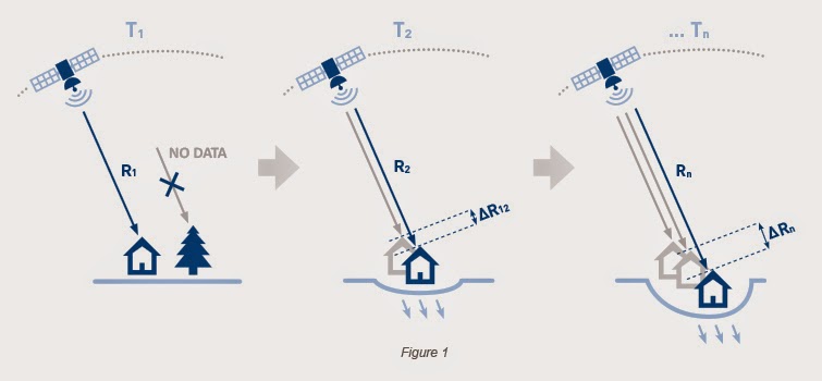
Figure 1 shows a
schematic representation of the PSInSAR approach.
This memo describes the ASCE Geotechnical Meeting that took
place at the Crown Plaza on October 1, 2014.
Meeting Description
Bruce Macdonald from Tre Canada presented a lecture about InSARTM
technology his firm uses to measure surface Deformation. Interferometric synthetic aperture radar,
abbreviated InSAR or IfSAR, is a radar technique used in geodesy and
remote sensing. He began the lecture
with a image of a satellite that orbits the earth. The satellite is position at one place, a
point on the earth’s meridian. It
gathers information. The earth
rotates.
DInSARTM is differential InSARTM. DInSARTM has a precision in
Centimeters. It is capable of gathering
information of a 3m x 3m earth surface.
Previous image provides 2321/Km2 points density. The new image provides 17,000/Km2
resolution. As advertised on the http://treuropa.com/technique/squeesar/
website, SqueeSARTM has identified many more ground points. This increases the overall understanding of
surface displacement occurring in an area of interest. SqueeSARTM uses algorithm that
offers significantly increased coverage of ground points especially over
non-urban areas.
Applications
Tre Canada mines the data from different government agency
satellites. The satellites are not their
own. However, obtaining the data and
correlating the data to the specific client need is a highly time consuming and
technically difficult task. Deformation
of the earth surface is a serious issue for the environment and the safety of
the community. Oil companies have to be
monitored by the government to meet the safety standards as they mine the
surface of the earth which causes deformation.
This technology is also used
to monitor landslide activities hazardous areas. The whole country of Italy has been monitored
by satellites for their frequent and ongoing land deformation, inventory of
existing cases of landslides and stabilizing program monitoring.
Lessons Learned
I learned a great deal of information during Bruce’s
presentation. Improvements are
rapid. TRE introduced SqueeSARTM
in 2010. There are companies that mine
these free satellite data to make a great profit. The cost for monitoring a small plot of land
of 3m x 3m can in as much as $100,000 USD.
The data needs to be processed.
Alogorithms are used to make sense of the data and organized into coherent
presentations that are useful to the client.
Conclusion
The field of GIS and satellite imaging is fascinating. The presentation display multi disciplines
and techniques. There is a bit of math
in the algorithms, a bit of geography, surveying, environmental, geotechnical
and business. Engineering field is comprehensive
and complex. Computer technology has
provided new techniques to better understand the planet earth. The future will benefit more from these
improvements and hopefully lower the costs of these satellite monitoring to
provide us information for studying the earth’s surface and provide a safer
living environment.
Attachments
Attachment A – Figure 1
Attachment A.
ΔR=λ/2π
.
No comments:
Post a Comment